Ninety Six National Historic Site

Decades before Richard Pearis founded Greenville in 1770, another town was the largest and most important “metropolis” in Upstate South Carolina. That town was Ninety Six.
As the most westerly English settlement, Ninety Six was an important administrative, trade, and strategic outpost. It was also the site of two battles during the American Revolution including the siege of the Star Fort at Neinty-Six which has gone down in history as the longest siege of the Revolution.
Click here to learn more about the history of Ninety-Six South Carolina
Visiting Ninety Six National Historic Site

After you parking, follow the path to the visitor’s center. Along the way, you’ll pass through a small plaza with informational signage. This includes some info about the park itself as well as the battles fought here as well as other interesting facts about the historic site.
At the visitor center, you can watch a 22 minute film documenting the siege of the Star Fort as well as the importance of the settlement to the British and why they were willing to so fiercely defend it. It’s always a good idea to check in with one of the rangers and ask about current conditions or to see what’s new. While you’re there, be sure to check out a mp3 player with a guided walking tour.
The Main Battlefield Trail

After leaving the visitor center it’s time to start your journey through history. The main trail is paved and easy to follow. In fact, as long as you’re on this trail you wont get lost. It’s mostly level as well with only a few slightly steep bits.

You’ll walk through a slightly wooded area at first stopping. There area a few historically significant spots along this part of the trail. You’ll find one when you cross over Island Ford Road which was used by the Patriot Army in 1781 as they moved to lay siege to the town.

Soon, you’ll find yourself on the edge of an open field and in the distance you can barely make out the remnants of the Star Fort. If you want, climb the two story observation platform to get a birds eye view of the battlefield. From up high you’ll have a better view than the Patriots who fought here in 1781.

Now follow the trail as it winds through the field to the fort. As you get close, you’ll pass a cannon and a reproduction rifle tower similar to the ones constructed during the siege. And finally, you’ll reach the Star Fort.

Almost two hundred and fifty years of erosion have taken its toll on the fort, but you can still see it’s outline and climb up on the walls. In fact the Star Fort at Ninety-Six Historic Site is the best preserved Revolutionary War earthen fortification in the entire nation.

As you move on passed the Star Fort, you’ll soon reach the site of the old fortified town of Ninety-Six. None of the buildings remain as they were all burned by the British when they abandoned the town, but the boundaries of where the town once stood are clearly marked as well as the locations of important buildings.

As soon as you pass through the site of the old town, you’ll see an old fort sitting at the top of a small hill. This is a partial reproduction of Holmes’ Fort which stood on this site helping defend this side of the town just as the Star Fort defended the other.

This is also the site of the first battle of the Revolutionary War fought in the Carolinas which was one of the earliest land battles of the war. In November of 1775 Patriot and Loyalist forces met here and shots were briefly exchanged. Although this early battle wasn’t anywhere near as fierce as later battles fought in the Carolinas, it did take the life of the first Patriot to fall in the South. A memorial to that man, James Birmingham lies along the trail just past the fort.

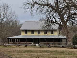
Now you’re nearing the end of the main trail. The final stop is the Andrew Long house. Although this two story log home isn’t original to the site, it does date to the 1700’s and is a good example of what a home in the area of Ninety-six would have been like during the colonial era.
Other Trails

There are other trails that split off of the main battlefield trail although none are as well maintained or significant as the main trail. The one exception is the Charleston Road that leads to the Goudey Trail. This detour is approximately 1.5 miles long.
Charleston Road crosses over the main trail near the site of the old town and as the name implies, it was the main road connecting Ninety-Six to Charleston as well as other settlements in the Carolinas.

If you take this side trip you’ll find yourself walking along a gravel road leading into the woods. Follow the signs and you’ll find yourself on a smaller trail that leads to the site of what was Robert Goudey’s Trading post. Built in 1751, it was the first European outpost in the area and an important point of trade between the colonies and the Cherokee.

If you continue past this site, you’ll find yourself walking through the woods where archaeologists have uncovered an old cemetery. Not much is know about it. It may date to colonial times and there is speculation that it was a slave cemetery. But it is preserved by the park service who have built a small fence around it.
Continue to follow this trail and it will loop back to Charleston Road where you can make your way back to the main trail.
Click here for a rundown of our visit to Ninety-Six National Historic Site
The History of Colonial Ninety Six

Situated Along the Cherokee Path
The Cherokee Path was a pack trail that ran from Charleston, through Fort Congaree near present day Columbia, and on to the Cherokee Town of Keowee. From there it connected with existing Cherokee trade routes between the other Lower Towns and the rest of the Cherokee Nation.
It was along this path that Thomas Brown received a land grant of 200 acres with the intention of building a trade hub in 1738. While it seems that he never developed the land, there are some records of trade along the path in the area of Ninety-Six around 1737. However, it wasn’t until Robert Goudey bought the land after Brown’s death in 1747 that the area began to take shape.
Goudey’s Trading Post
Robert Goudey had lived among and traded with the Cherokee for many years before settling at Ninety Six. He brought with him a supply of firs and other goods, and was quickly able to establish his trading outpost as a vital link between Keowee and Charleston.

By 1753 the town of Ninety Six was primarily Goudy’s Trading Post, his home, barn, and outbuildings. He supplied traders with such items as rum, sugar, and gunpowder.
Ninety Six District
Thanks to it’s location on a vital trade route, Colonial Ninety Six continued to grow and prosper. In time the village grew to over 100 settlers including merchants, lawyers, hotel keepers, and physicians. The town also had a library, an academy, and a church.

Due to it’s growing importance and the fact that 12 roads passed through the town, Ninety Six was the logical location for the administrative seat of the 96 District. By 1768 the most westerly district in the province of South Carolina was established and centered at the town of Ninety Six.

A courthouse and gaol (jail) were built just outside the town perimeter. The juridical district not only included the surrounding areas of modern day Greenwood and Newberry Counties, but stretched as far away as Spartanburg and Union, and included parts of Cherokee and Greenville Counties as well. All that lay west of 96 District were Cherokee lands.
Of Patriots and Loyalists

Far away in Charleston, the wealthy merchants and land owners along the coast were taking up the Patriot Cause. The Provincial Congress was formed as a shadow government in 1775 and sought to wrestle power away from Lord William Campbell, the last British Governor of South Carolina.
As Lord Campbell felt his hold on power loosening, he did his best to discredit the Provincial Congress and the Patriot Cause in the Carolina back country. Even as he fled his home for the safety of the British warship HMS Tamar, his efforts in the back country paid off.
While Charleston was firmly in the hands of the Patriots in 1775, the Loyalists had a strong following in the back country. The divisions between Patriots and Loyalists in South Carolina would persist throughout the entire war. Making the War of Independence in the Carolinas not only bloody but America’s first Civil War as well.
The Looming Shadow of War
By August of 1775, both Patriots and Loyalists had massed large militias. The Carolina back country was a powder keg just waiting for a spark. That spark came in October when Loyalists captured a shipment of gunpowder and ammunition that the Provincial Congress sent to the Cherokee.
Major Andrew Williamson was already in the area recruiting for the Patriot cause. In November, he and his army of 560 men approached Ninety Six. After hearing that Captain Patrick Cunningham and Major Joseph Robinson were leading a large Loyalist force in his direction and believing the town to be indefensible, Williamson moved his men to the nearby plantation owned by John Savage and ordered the construction of an improvised stockade.
The next day, a Loyalist force of 1900 surrounded the camp. From November 19th to 21st 1775, the Loyalists lay siege to Williamson’s army. For two days they tried to route the Patriots to no avail. Finally word came that Patriot Colonel Richard Richardson and his Camden militia of over 4000 men may be in the area searching for the stolen munitions, the Loyalists approached the fort under a flag of parley. Both sides agreed to withdraw and the Patriots agreed to destroy the fort.

The Loyalists lost four men during the siege while the Patriots lost only one. James Birmingham was the first Patriot casualty in the Carolinas during the Revolution, but he wouldn’t be the last.
A Loyalist Stronghold
The back country may have had split loyalty, but the administrative town of Ninety Six quickly became Loyalist stronghold.

After retaking Charleston in 1780, Ninety Six became the linchpin of British plans in the back country. From here they hoped to control the interior of the state, recruit and protect Loyalists, and pacify Patriot forces in the back country. To that end, they set about fortifying the town.
The major fortification was the Star Fort. Built on the eastern side of the town, the bastion fort of about a half acre consisted of 14 foot earthen walls surrounded by sandbags for a total height of 17 feet. The eight pointed star design gave the troops garrisoned inside command of a 360 degree area around the fort with no blind spots.

A smaller stockade fort was built on the Western side of town across a small stream to not only protect the town but also the stream. The town was also garrisoned.
Siege of Star Fort at Ninety Six
After a number of blunders by Horatio Gates, Nathanael Greene as appointed commander of the Southern Department of the Continental Army on October 14, 1780. He immediately set about harassing British forces and lead a guerrilla campaign against Cornwallis during the winter of 1781.
When Cornwallis moved into Virginia in April, Greene turned his attention to eliminating the British presence in South Carolina. He captured a number of small British forts during April and on May 22, he arrived at Ninety Six intending to do the same.
Greene’s engineers began by digging zig zaging trenches towards the Star Fort. By June 10, they were within 30 yards of the fort.
In attempt to resolve the siege, Patriot engineers dug a tunnel under the battlefield to try to get explosives under the walls of the fort. When the walls were breached, Patriots from nearby trenches could storm the fort. However, the mine would not be finished by the time of the assault. Work began on June 9.
On June 13, British defenders awoke to find that the Patriots had constructed a rifle tower so they could fire down into the fort. The British quickly countered by placing sandbags around the earthen walls of the fort and the siege continued.
Then word came of British reinforcement marching from Charleston to help defend the fort. Greene had to decide whether to attack before all preparations were made or to abandon the siege. After consultations with his men, on June 18 a final push was made to capture the fort. After heavy losses, Greene ordered a retreat and the longest siege of the American Revolution Ended.
American forces suffered 147 casualties compared with 85 British. Although the siege wasn’t successful, it made the British reconsider having an outpost so far away from their supply lines in Charleston. So as Nathanial Green was retreating with his men in advance of a British force from Charleston, Ninety Six and all fortifications were abandoned and burned by the British.
Post War Resurgence and Decline
After the Revolution, the Ninety Six was rebuilt just a few hundred yards away from the original settlement. In 1785 the 96 District was subdivided into counties. Each county was responsible for maintaining courthouses and jails and the importance of Ninety Six as the administrative center of the large district declined and its courthouse shut down.
Also in March of 1785 it became the site of one of three colleges established by the General Assembly. By 1787, Ninety Six had renamed itself Cambridge in honor of the local college. But the school soon failed, and by the 1820’s one of the most fought over towns in South Carolina was almost gone.


Fast Facts About Ninety Six National Historic Site
| Type: | National Historic Site |
| Admission: | Free |
| Location: | 1103 SC-248, Ninety Six, SC 29666 |
| Website: | https://www.nps.gov/nisi/index.htm |
| Phone | (864)543-4068 |
Things to do: Walking, learn about history, picnicking, audio tour